Winter and snowshoe hiking in Tuxertal
During a winter holiday in the Tux-Finkenberg holiday region in the Zillertal, around 68 km of winter hiking trails, some of which have only been rolled down, cleared or cleared, ensure a winter variety.
The winter hiking trails to the Eggalm or the Sommerbergalm are a challenge - rustic huts and the panorama restaurants with Zillertal specialties await as a reward. Those who prefer to experience the great view comfortably can take the cable cars to the individual mountain stations.
Experience snowy landscapes and a glittering sea of 1,000 snow diamonds on your winter holiday in the Zillertal. Enjoy a snowshoe hike in untouched nature, where you get to know many new impressions of the snow-covered Zillertal mountains away from the slopes. Experienced mountain guides accompany you to the most beautiful places in the Tux-Finkenberg holiday region.
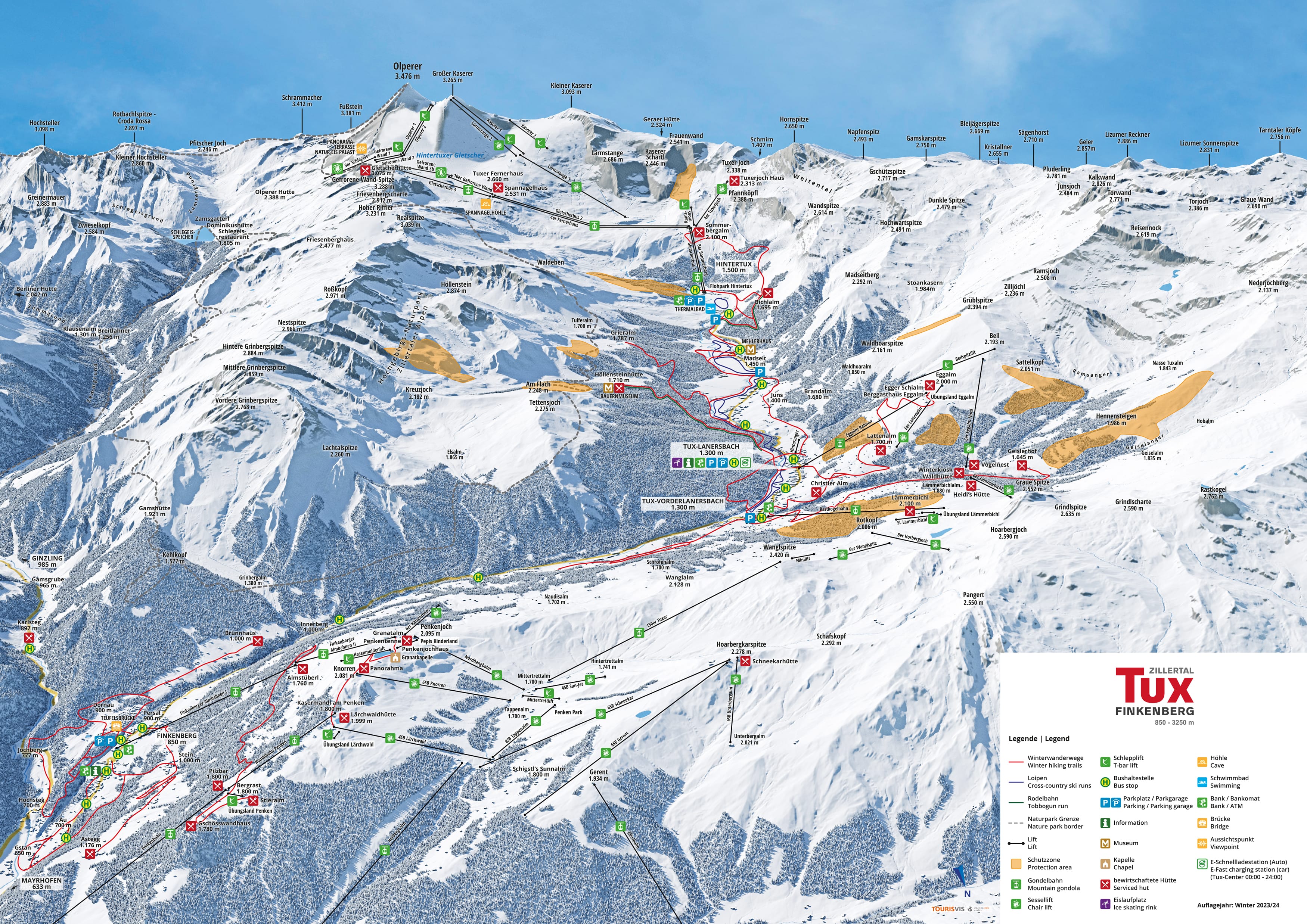
Overview of winter hiking trails
Start: Sommerbergalm
End: Hintertux
Path number: 17, 11
- Route: 7 km
- Walking time: 2 h
- Metres in altitude uphill: 15 m
- Metres in altitude downhill: 560 m
- One way hike
- Gondola
Start: Hintertux Dorf/Gletscherbahn
End: Hintertux Dorf/Gletscherbahn
Path number: 17, 15, 11, Toboggan run
- Route: 5 km
- Walking time: 2 h
- Metres in altitude uphill: 260 m
- Metres in altitude downhill: 240 m
- Circular hike
- Illuminated toboggan run
Start: Tux-Vorderlanersbach
End: Hintertux
Path number: 10, 12, 11
- Route: 10 km
- Walking time: 3 h
- Metres in altitude uphill: 350 m
- Metres in altitude downhill: 80 m
- One way hike
Start: Tux-Lanersbach Hinteranger
End: Tux-Lanersbach Hinteranger
Path number: 21, 10
- Route: 7 km
- Walking time: 2 h
- Metres in altitude uphill: 200 m
- Metres in altitude downhill: 200 m
- Circular hike
Start: Tux-Lanersbach
End: Höllensteinhütte
Path number: 28, Rodelbahn
- Route: 3,8 km
- Walking time: 1,5 h
- Metres in altitude uphill: 410 m
- One way hike
- Illuminated toboggan run
Start: Bergstation Eggalm Bahnen
End: Talstation Eggalm Bahnen
Path number: 39, 21
- Route: 6,3 km
- Walking time: 2 h
- Metres in altitude downhill: 670 m
- One way hike
- Gondola
Start: Tux-Vorderlanersbach
End: Tux-Vorderlanersbach Dorfplatz/Rastkogel Bahnen
Path number: 21, 10
- Route: 4,5 km
- Walking time: 1,5 h
- Metres in altitude uphill: 200 m
- Metres in altitude downhill: 200 m
- Circular hike
Start: Tux-Lanersbach
End: Tux-Lanersbach
Path number: 30,10
- Route: 3,8 km
- Walking time: 1,5 h
- Metres in altitude uphill: 210 m
- Metres in altitude downhill: 200 m
- Circular hike
Start: Dorfplatz Tux-Vorderlanersbach
End: Geislerhof
Path number: mountain road
- Route: 4 km
- Walking time: 1,5 h
- Metres in altitude uphill: 380 m
- One way hike
Start: Tux-Vorderlanersbach Dorfplatz
End: Tux-Vorderlanersbach Außertal/Naustein
Path number: 63, 65
- Route: 2,1 km
- Walking time: 0:45 h
- Metres in altitude uphill: 55 m
- Metres in altitude downhill: 70 m
- One way hike
Start: Finkenberg, Teufelsbrücke
End: Finkenberg, Teufelsbrücke
Path number: 33b, 34
- Route: 4,5 km
- Walking time: 1,5 h
- Metres in altitude uphill: 200 m
- Metres in altitude downhill: 200 m
- Circular hike
Start: Finkenberg, Teufelsbrücke
End: Finkenberg, Teufelsbrücke
Path number: 32, 32b
- Route: 2 km
- Walking time: 1 h
- Metres in altitude uphill: 100 m
- Metres in altitude downhill: 100 m
- Circular hike
Start: Finkenberg, Teufelsbrücke
End: Finkenberg, Teufelsbrücke
Path number: 33, 33a, 30, 32
- Route: 4,5 km
- Walking time: 1,5 h
- Metres in altitude uphill: 200 m
- Metres in altitude downhill: 205 m
- Circular hike
Start: Finkenberg Dorf Kirche
End: Finkenberg Dorf Kirche
Path number: 26, 26a, 12, 31a, 26c
- Route: 3,5 km
- Walking time: 1,5 h
- Metres in altitude uphill: 215 m
- Metres in altitude downhill: 215 m
- Circular hike
Start: Finkenberg Dorf Kirche
End: Finkenberg Dorf oder Persal
Path number: 25
- Route: 6,5 km
- Walking time: 2,5 h
- Metres in altitude uphill: 335 m
- Metres in altitude downhill: 335 m
- Up & Down hike
Start: Finkenberger Almbahnen Mittelstation
End: Finkenberger Almbahnen Penkenjoch
- Route: 6,7 km
- Walking time: 2:15 h
- Metres in altitude uphill: 290 m
- Metres in altitude downhill: 220 m
- Circular hike
- Gondola
BergWaldWeg
- Route: 4,7 km
- Walking time: 1,5 h
- Metres in altitude uphill: 190 m
- Metres in altitude downhill: 230 m
WinterWanderWeg Penken
- Route: 2 km
- Walking time: 45 min.
- Metres in altitude uphill: 100 m


Destination address for the tourist information:
A-6293 Tux, Lanersbach 401
Plan your route online:
Detailed information on how to get to Tux-Finkenberg by bus is available here.
The airports at Innsbruck, Salzburg and Munich are between 90 and 230 km from Tux-Finkenberg.
Here you can find the flight shedules of Innsbruck